What Is the Difference Between Satellite Radar Pictures
Satellite radar pictures use microwave signals to capture images of Earth, unlike optical satellites that rely on sunlight. They can see through clouds, rain, and darkness, making them invaluable for all-weather monitoring. Understanding the difference between satellite radar pictures and traditional satellite imagery helps you choose the right data for your needs.
Satellite radar pictures are a fascinating and powerful tool in modern imaging technology. If you have ever wondered how we get images of Earth from space when it is cloudy or dark, the answer lies in radar. Unlike traditional cameras that need light, radar satellites send out their own signals and listen for what bounces back. This makes them incredibly useful for a wide range of tasks.
In this article, we will break down exactly what satellite radar pictures are, how they work, and how they differ from other types of satellite images. Whether you are a student, a professional, or just curious about space technology, this guide will give you a clear understanding of this important imaging method.
Key Takeaways
- Radar satellites emit their own signals: They don’t need sunlight like optical imaging systems.
- All-weather capability: Satellite radar pictures penetrate clouds, rain, and darkness with ease.
- Two main types exist: SAR (Synthetic Aperture Radar) and real-aperture radar serve different purposes.
- Different from optical imagery: Radar images look completely different from regular photographs taken from space.
- Wide range of applications: From tracking oil spills to measuring ground movement, radar satellites are incredibly versatile.
- Resolution varies by mission: Some radar satellites capture fine details while others cover vast areas with broader resolution.
📑 Table of Contents
- What Are Satellite Radar Pictures?
- How Satellite Radar Differs from Optical Imaging
- Types of Satellite Radar Imaging
- Key Differences Between Radar and Optical Satellite Images
- Applications of Satellite Radar Pictures
- How to Read and Interpret Radar Images
- Common Mistakes When Working with Satellite Radar Data
- Conclusion
What Are Satellite Radar Pictures?
Satellite radar pictures are images of Earth created using radar technology mounted on satellites orbiting our planet. These satellites send out microwave pulses toward the surface and measure the energy that comes back. The result is a detailed image that shows the shape, texture, and composition of the ground below.
Think of it like shining a flashlight in a dark room. You do not need the room to be lit by the sun. You create your own light and see what the light hits. That is essentially how satellite radar works. The satellite sends out radar waves, and the bounced signals create an image.
This is very different from optical satellite images, which work like a regular camera. Optical satellites capture sunlight reflected off Earth’s surface. When clouds block the sunlight, optical satellites cannot see through them. Radar satellites do not have this problem at all.
How Radar Satellites Capture Images
The process starts with a radar instrument on the satellite. This instrument sends out microwave pulses in a specific direction. These pulses travel through the atmosphere and hit the Earth’s surface. When they hit the ground, some of the energy bounces back toward the satellite.
The satellite’s receiver measures the time it takes for the signal to return. It also measures the strength of the returned signal. Using this data, the satellite builds a detailed picture of what is below. The entire process happens very quickly, often multiple times per second.
One key advantage of this approach is that it works day and night. Since the satellite provides its own illumination, it does not depend on the sun. This means radar satellites can capture images at any time of day or night, in any weather condition.
How Satellite Radar Differs from Optical Imaging
The difference between satellite radar pictures and optical satellite images is fundamental. Optical imaging relies on visible light, just like the camera on your phone. Radar imaging uses microwave energy, which is invisible to the human eye. This difference leads to several important distinctions.
When you look at an optical satellite image, it looks like a photograph. You can see roads, buildings, forests, and rivers just as you would see them from an airplane. Optical images are intuitive and easy to interpret. They look like what your eyes would see from space.
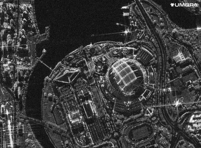
Radar images, on the other hand, look very different. They often appear as shades of gray with unusual textures. The way the radar signal interacts with surfaces creates patterns that can be hard to read at first glance. But with experience, these images reveal incredible detail about surface roughness, moisture content, and even the material composition of objects below.
For example, think about how a smartphone camera works compared to a specialized inspection camera. Just as the iPhone camera flower lens feature uses specialized optics for close-up imaging, radar satellites use specialized microwave sensors for all-weather imaging. Each tool serves a different purpose based on the technology it uses.
Weather and Lighting Advantages
The biggest advantage of radar over optical imaging is its ability to see through clouds and darkness. Optical satellites are essentially blind during heavy cloud cover or at night. This is a major limitation for many applications.
Radar satellites do not care about clouds or darkness. Microwaves pass through clouds, rain, and smoke with very little loss of signal. This means radar satellites can provide consistent, reliable imagery regardless of weather or time of day. For disaster response and environmental monitoring, this capability is absolutely critical.
Types of Satellite Radar Imaging
Not all radar satellites work the same way. There are different types of radar imaging technology, each with its own strengths and weaknesses. Understanding these types helps you appreciate the full range of what radar satellites can do.
Synthetic Aperture Radar (SAR)
SAR is the most common type of radar imaging used on satellites. It uses a technique called synthetic aperture to create high-resolution images from a relatively small antenna. The satellite moves along its orbit and collects radar data over time. By combining these measurements, it creates a much larger effective antenna, known as a synthetic aperture.
This technique allows SAR satellites to produce incredibly detailed images. Some SAR systems can resolve objects as small as a few meters across. The resolution depends on the frequency band used and the altitude of the satellite.
SAR is used for many important applications. It helps scientists track changes in ice sheets, monitor deforestation, and detect oil spills on the ocean. It is also used for military surveillance and border monitoring. The versatility of SAR makes it one of the most valuable tools in remote sensing.
Real-Aperture Radar (RAR)
Real-aperture radar uses a physical antenna to send and receive radar signals. This is the simpler, older form of radar imaging. RAR systems produce lower resolution images compared to SAR because the antenna size limits the resolution.
RAR is still used in some applications where very high resolution is not needed. For example, it can be used for broad-scale weather monitoring or large-area surveillance. However, for most modern applications, SAR has replaced RAR due to its superior image quality.
Interferometric Synthetic Aperture Radar (InSAR)
InSAR is an advanced form of SAR that uses two or more radar images taken from slightly different positions. By comparing these images, scientists can measure tiny changes in the Earth’s surface. This technique can detect ground movement as small as a few millimeters.
InSAR is incredibly useful for monitoring earthquakes, volcanoes, and landslides. It helps engineers track the stability of buildings, dams, and infrastructure. This technology has saved lives by providing early warning of ground instability.
Key Differences Between Radar and Optical Satellite Images
Understanding the difference between satellite radar pictures and optical satellite images is essential for choosing the right data source. Here is a detailed comparison of the two approaches.
| Feature | Radar Satellite Images | Optical Satellite Images |
|---|---|---|
| Light Source | Own radar signal (active) | Sunlight (passive) |
| Cloud Penetration | Yes, passes through clouds | No, blocked by clouds |
| Night Imaging | Yes, works in darkness | No, requires sunlight |
| Image Appearance | Grayscale with texture | Natural color or false color |
| Surface Detail | Roughness and moisture | Visual appearance |
| Weather Dependence | Minimal | High |
| Interpretation | Requires training | Intuitive for most users |
| Cost | Generally higher | Varies widely |
When you compare these two imaging methods, it is clear that each has its own strengths. Optical images are easier to understand and interpret. They look like photographs, which makes them accessible to a wide audience. Radar images require more expertise to read, but they provide information that optical images simply cannot.
For instance, if you want to compare different types of cameras, think about how a point-and-shoot camera differs from a DSLR. Each serves a different purpose based on its design and capabilities. The same principle applies to radar versus optical satellite imaging. Each technology is optimized for different conditions and applications.
When to Use Radar vs. Optical
Choose radar satellite images when you need all-weather, day-and-night capability. Radar is ideal for monitoring floods, tracking sea ice, and detecting surface changes over time. It is also the best choice for areas with frequent cloud cover, such as tropical rainforests.
Choose optical images when you need visually intuitive data. Optical images are better for land use mapping, vegetation analysis, and urban planning. They are also easier for non-experts to interpret and share with others.
Applications of Satellite Radar Pictures
Satellite radar pictures are used across many industries and fields. Their unique capabilities make them essential for tasks that optical satellites cannot handle. Let us explore some of the most important applications.
Disaster Response and Management
When a natural disaster strikes, time is critical. Radar satellites can provide images of affected areas regardless of weather conditions. This is crucial during floods, hurricanes, and earthquakes when clouds often block optical satellites.
Radar images help emergency responders identify flooded areas, assess damage to infrastructure, and plan rescue operations. The ability to see through clouds and operate at night gives radar satellites a decisive advantage in disaster scenarios.
Environmental Monitoring
Scientists use radar satellite data to monitor changes in our environment over time. Radar can detect deforestation, track the melting of polar ice caps, and measure changes in wetland areas. These observations help us understand and respond to climate change.
Radar is also used to monitor ocean health. It can detect oil spills, measure sea surface roughness, and track ship movements. This information is vital for protecting marine ecosystems and enforcing environmental regulations.
Agriculture and Land Use
Farmers and agricultural scientists use radar data to monitor crop health and soil moisture levels. Radar signals are sensitive to the water content in soil and plants. This allows for precise monitoring of agricultural conditions even when fields are obscured by clouds or during nighttime operations.
Radar imaging also helps with land use planning. It can map urban expansion, track infrastructure development, and monitor changes in land cover over time. This information supports smart city planning and sustainable development.
Military and Security
Radar satellites play an important role in defense and security. Their ability to image any location at any time makes them valuable for surveillance and reconnaissance. Radar can detect vehicles, buildings, and other objects regardless of lighting or weather conditions.
Military organizations also use radar data for border monitoring, tracking ship movements, and detecting unauthorized activities. The all-weather capability of radar ensures continuous coverage when it matters most.
Geological and Infrastructure Monitoring
Radar satellites are used to monitor the stability of the Earth’s surface. InSAR technology can detect ground subsidence, landslides, and tectonic movements. This helps engineers and geologists assess risks to buildings, roads, and other infrastructure.
For example, radar data has been used to monitor the stability of dams, bridges, and tall buildings. By detecting millimeter-scale ground movements, radar satellites can alert authorities to potential structural problems before they become dangerous.
How to Read and Interpret Radar Images
Reading radar images is a skill that takes practice. Unlike optical images that look like photographs, radar images have a unique appearance that can be confusing at first. Understanding a few basic principles will help you interpret these images more effectively.
In radar images, brighter areas usually indicate surfaces that reflect more radar energy back to the satellite. Smooth surfaces like calm water or flat roads tend to appear dark because they reflect the signal away from the satellite. Rough surfaces like forests, urban areas, or rocky terrain appear brighter because they scatter the signal back toward the satellite.
Water bodies typically appear very dark in radar images. However, if the water has waves or ripples, it may appear brighter. Oil spills on the ocean appear very dark because they smooth the water surface and reduce radar reflection. This is a powerful tool for detecting and monitoring oil pollution.
Urban areas often appear bright in radar images because buildings and other structures create many surfaces that reflect radar signals. The geometry of buildings can also create shadows in radar images, similar to how shadows appear in optical photographs.
If you are new to radar imagery, it helps to compare radar images with optical images of the same area. This comparison will help you learn to recognize features in radar data. Just as understanding the gully camera inspection technology requires knowing how specialized cameras work, interpreting radar images requires understanding the underlying radar principles.
Common Mistakes When Working with Satellite Radar Data
Working with satellite radar data comes with its own set of challenges. Here are some common mistakes to avoid.
- Assuming radar images look like photographs: Radar images have a very different appearance. Do not expect them to look like regular photos.
- Ignoring the radar angle: Radar satellites image the surface at an angle, not straight down. This affects how features appear in the image.
- Overlooking speckle noise: Radar images often contain grainy noise called speckle. This is a natural characteristic of radar imaging and can be reduced through processing.
- Neglecting calibration: Radar data must be properly calibrated for accurate analysis. Skipping this step can lead to incorrect interpretations.
- Comparing radar and optical data directly: These two types of data measure different properties. Always consider what each type of image actually represents.
Conclusion
Satellite radar pictures represent a remarkable advancement in imaging technology. They allow us to see our planet in ways that traditional cameras simply cannot. The ability to capture images through clouds, rain, and darkness makes radar satellites indispensable for many applications.
The key difference between satellite radar pictures and optical images comes down to the technology used. Radar uses its own microwave signals, while optical imaging depends on sunlight. Each approach has its strengths, and they are often used together to provide the most complete picture of our world.
As radar technology continues to improve, we can expect even more detailed and useful satellite radar images in the future. Understanding how these images work and how to interpret them will become an increasingly valuable skill across many fields. Whether you are monitoring the environment, responding to disasters, or planning infrastructure, satellite radar pictures offer capabilities that no other imaging technology can match.
Frequently Asked Questions
What makes satellite radar pictures different from regular satellite photos?
Satellite radar pictures use microwave signals that the satellite sends out itself, while regular satellite photos rely on sunlight reflecting off Earth’s surface. This means radar images can be captured at any time of day or night and can see through clouds and rain, unlike optical photos which need clear skies and sunlight.
Can satellite radar see through clouds?
Yes, satellite radar can see through clouds, rain, and even smoke. Microwaves used by radar satellites pass through atmospheric conditions that would block visible light. This all-weather capability is one of the biggest advantages of radar imaging over optical imaging.
What does a satellite radar image look like?
Satellite radar images typically appear as grayscale pictures with unique textures. They do not look like regular photographs. Smooth surfaces like water appear dark, while rough surfaces like forests or urban areas appear bright. The images can look unusual at first but reveal important details about surface roughness and moisture.
Are satellite radar images hard to interpret?
Satellite radar images require some training to interpret effectively. They look very different from optical images, which can make them confusing for beginners. However, with practice and by comparing radar images with optical images of the same area, most people can learn to read and understand radar data.
What are the main uses of satellite radar pictures?
Satellite radar pictures are used for disaster response, environmental monitoring, agriculture, military surveillance, and infrastructure monitoring. They are especially valuable for tracking floods, detecting oil spills, monitoring ice sheets, and measuring ground movement. Their all-weather capability makes them essential for many applications.
How is satellite radar technology evolving?
Satellite radar technology is constantly improving. New satellites offer higher resolution images, faster data collection, and more advanced processing capabilities. Interferometric radar (InSAR) is becoming more sophisticated, allowing scientists to detect ground movements as small as a few millimeters. Future developments will make radar satellite data even more accessible and useful.